Apr 21, 2022
Research indicates that the impact of infrastructure construction on permafrost is more rapid than the climatic changes currently impacting the Arctic as a whole. Knowledge of where ice-rich permafrost exists is a first step to limiting the impact by the simple step of avoiding construction of infrastructure on ice-rich ground where possible. This step as been a basic part of the philosophy of road construction in Alaska since the 1950s.
Unfortunately, many Alaskan villages are built on ice-rich ground that is thawing due to the dual impacts of climate change and infrastructure construction. In some cases, the issues are extreme enough that the entire community needs to be relocated. New sites should be chosen to ensure the community will be sustainable.
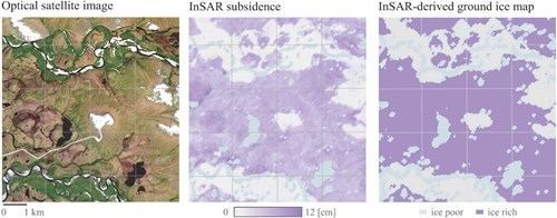
Simon Zwieback, a remote sensing faculty at the UAF Geophysical Institute studies how to use remote sensing data to map ice-rich permafrost. The overarching goal is to identify areas that are susceptible to subsidence and instability on regional scales using satellite data. He recently published a paper in The Cryosphere examining the area around Kivalina, Alaska which contains an outlook into how such data could help in future planning and relocation efforts.
These novel satellite data analyses can enhance the mapping of permafrost excess ground ice and the susceptibility to terrain instability. The practical advantages include the pan-Arctic availability of data, the ease of automation, the independence from costly in situ observations, and its applicability in absence of visible manifestations of ground ice. As such the information obtained can be used to identify areas for further examination on the ground for suitability for infrastructure construction.